Fallacies
Fallacy #1: The Earth is Round
Life for cartographers (and GIS technicians) would be a breeze if the earth had been flat as was originally believed. We could lay a simple XY grid over the surface with an origin proximate to our area of interest, choose a measurement unit, and pretty accurately define and describe locations (x units east or west of the origin, y units north or south of the origin). However, the earth is not flat. And it is also not a perfect sphere. Gravity and the irregular density of the mantle cause the earth to bulge slightly at the equator. New technologies are improving our ability to measure the earth’s shape.
Geodesists have developed and are constantly improving a system for simplifying and modeling the shape of the earth to improve the accuracy with which we can measure and map locations.
The model starts with a shape that approximates the slightly non-spherical shape of the earth. If we took a cross section of the earth, we could coarsely describe it as an ellipse. It is wider at the equator. The long axis is called the major axis, the shorter axis is the minor axis. Half the length of each axis is called the semi-major or semi-minor axis. Now, rotate the ellipse on the minor axis and the resulting 3-dimensional shape is called an ellipsoid. GIS literature uses the terms spheroid and ellipsoid interchangeably. And most coordinate systems or spatial references refer to this shape as a spheroid and not an ellipsoid even if they have axes of differing lengths. I will refer to this proximate earth shape as a spheroid here out but visualize a slight ellipse.
So. The spheroid gives us a simplified mathematical model of the earth’s shape. Over time, as measurement technologies have improved, our understanding of and ability to model the ellipsoidal shape of the earth have improved. Some spheroids attempt to model the whole earth, some focus on specific hemispheres or continents. In these cases, the portion of the spheroid that best models the earth shape in a particular region is used and the rest of the spheroid is largely ignored. The table below has a comparison of the heights and widths of the three major spheroids employed in North America.
| Spheroid | Semi-major Axis (m) | Semi-minor (m) |
|---|---|---|
| Clarke 1866 | 6,378,206.40 | 6,356,583.80 |
| GRS 1980 | 6,378,137.00 | 6,356,752.31414 |
| WGS 1984 | 6,378,137.00 | 6,356,752.31424518 |
To further refine our ability to measure locations, we also need to develop a systematic way to describe the height of the surface, or establish a uniform way to describe a baseline for each spheroid from which to make height measurements. We could use sea level, but of course, the sea isn’t level.
Fallacy #2: Sea Level
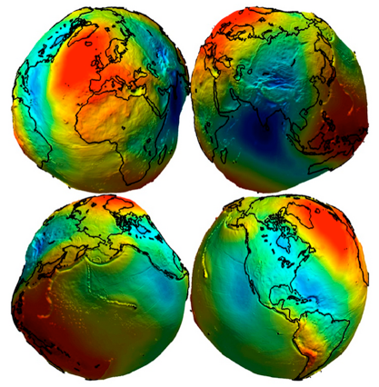
The sea has different ‘heights’ depending on tides, currents, and gravity. So the sea isn’t level to the point where we could use its elevation as a consistent origin for global elevations. If we hypothetically stopped the earth’s spin (but maintained gravity) and tunneled under and through the continents, the water on the earth’s surface would settle and come to equilibrium. But it wouldn’t be ‘level’. The water surface would have valleys and hills; pulled down in places where gravity is stronger and sitting higher in places where there is relatively less gravity. We could measure this theoretical water surface or skip to the chase and simply measure gravity around the world and create a “surface” defined by gravitational pull. This equipotential gravitational surface is called a geoid and we combine the concept of a geoid with spheroids to enhance our ability to model the earth’s shape. Can you see how the spheroid gives us a modelable surface for north/south and east/west measurements and the geoid gives us a modelable origin for elevation?
Fallacy #3: Gravity Isn’t a Constant
Gravity varies around the world and so gravitational forces are not always perpendicular to the surface. The geoid is defined by the directional pull of gravity as well as the spatially variable forces of gravity.
In the figure to the right, red areas are regions with higher gravitational pull and blue areas have lower gravitational pull.