Water Research to Operations: USU's Role in a National Consortium
By Alyssa Regis |
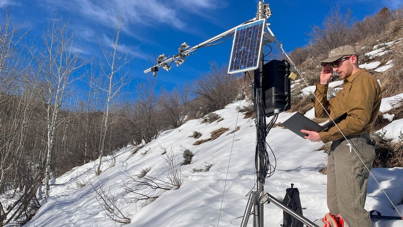
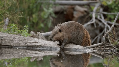
Graduate student Braedon Dority checks snow sensing stations up Logan Canyon as part of a CIROH-funded project to provide better data for modeling snow.

Operational application of research knowledge is critical for decision-making when it comes to flooding and water resources, but to get there, researchers must build bridges with government agencies and private entities to get research into the hands of those who operate our water management systems.
The Cooperative Institute for Research to Operations in Hydrology, or CIROH, is one such bridge. CIROH is a national consortium committed to advancing water prediction and building community resilience to water-related challenges. It is made up of 28 academic, government and private institutions, including Utah State University.
CIROH’s purpose is to link research at universities to the operational work of federal agencies like the National Oceanic and Atmospheric Administration office of water prediction and the United States Geological Survey, who operate national-scale infrastructure for measurement and forecasting of streamflow, floods, drought and water quality.
Through CIROH, the Utah Water Research Laboratory partners with other universities on cutting-edge research and water resources technologies. Linked together, researchers can aid federal agencies in solving important water-related issues.
“CIROH is unique in that it has a specific focus on translating research to operations,” said Professor Jeff Horsburgh, USU’s CIROH representative. “It’s about getting our work into the hands of the people who can benefit the most, and the national-scale collaborations across universities means that we can capitalize on the deep experience of a broad water science community.”
CIROH is building on several ongoing initiatives involving the UWRL:
- HydroServer: An open-source software stack for collecting, storing, managing and sharing observations from environmental sensors.
- HydroLearn: A platform with over 50 customizable courses, enabling instructors to collaboratively create, adopt, adapt and share hydrology and water resources engineering learning resources.
- HydroShare: A web-based community Hydrologic Information System for sharing hydrologic data and models. It enables collaboration on critical water issues across the country and enhances transparency and reproducibility of research.
The UWRL has multiple projects funded through CIROH, totaling over $4 million in research funds focused on building research partnerships and expanding operational capabilities in the field. These projects inform water resources planning and strengthen the research community.
Cameras for Hydrologic Monitoring
Camera-based monitoring systems can complement and, in some cases, replace conventional streamflow measurement technology, but scientific and operational challenges hinder widespread implementation.
Sierra Young and Jeff Horsburgh are integrating computer vision algorithms and machine learning into a low-cost camera-based monitoring system. This system can collect data in difficult-to-access areas, intermittent streams and areas where it may be difficult to install a more traditional gage.
Geospatial Framework for Channel Modeling
Realistic representation of channel and floodplain attributes is critical to understanding river networks, including accurate predictions of streamflow and inundation during floods.
Belize Lane and Colin Philips are developing a new geospatial framework that links directly with national-scale databases of river networks and catchments to improve the representation of channel and floodplain properties in hydrologic models. The researchers are creating regression models in this framework to estimate key channel and floodplain properties.
Improving Low-Flow Groundwater Estimates in the NextGen Framework
Groundwater contributions to streams are critical to sustaining streamflow during drought periods, but current NextGen Framework models rely on non-localized groundwater reservoir-discharge relations, and seasonal dry periods can create discrepancies in the system.
Pin Shuai is enhancing predictions of low flows by refining the concepts and parameters of subsurface flows. He is developing a dataset of subsurface hydraulic properties for the NextGen database of watershed properties across the continental U.S. This will provide more accurate insights for water management decisions.
Developing Lower-Cost Snow Sensing Stations
This multi-institution project focuses on developing lower-cost snow sensing stations to provide better data for modeling snow. These stations are designed to augment the current SNOTEL monitoring network and provide enhanced information about how snow accumulates and melts in different landscape settings.
Data from the snow sensing stations are integrated with an operational hydrologic information system to deliver near-real-time data. Models using this data can then be used to examine the impacts of snow processes on streamflow and water supply.
Enhanced Probabilistic Flood Inundation Mapping
Flood inundation mapping is a key part of assessing flood risk during high flows. Colin Philips and Belize Lane are working to enhance the accuracy of this mapping process by incorporating hydraulic and river corridor terrain variability. This is accomplished through development of a probabilistic synthetic rating curve. Flooding rivers are described by a family of these curves, and incorporating variability and uncertainty via this probabilistic curve will improve flood inundation mapping and reduce the risk of flood hazards to the public.
Forecasting in Managed Watersheds
Humans affect streamflow through reservoir operations, diverting water, return flows and more. The current national databases used to represent water flow within most hydrologic models only include natural variables, but hydrology and water supply are heavily influenced by humans, making it difficult to accurately forecast without accounting for water management.
Pin Shuai is working to expand the existing database of river and watershed properties to include water management infrastructure such as reservoirs and canals and integrate that information in models for water management.
Detecting harmful algal blooms using satellite hyperspectral data
Harmful cyanotoxins in aquatic environments often result in harmful algal blooms that threaten public health.
Sierra Young’s project aims to advance harmful algal bloom detection and species classification using satellite hyperspectral data. Remote sensing is frequently used for bloom monitoring, but challenges remain in accurately determining abundance and species type. To identify bloom-causing species and improve accuracy, Young’s team will integrate satellite imagery, drone imagery, and on-site field data into a machine-learning approach.
HydroLearn: Training Workshop and Models
There is a gap between what students learn in the classroom and the skills needed by government and industry organizations for operational hydrology forecasting. To teach students real-world skills in operational hydrology and support the educational mission of CIROH, David Tarboton is working with a team to create online learning modules for the HydroLearn platform. These modules connect theory to authentic problems and provide resources for faculty to elevate learning across the community.
HydroShare: Enhancing Collaboration via Data and Model Sharing
HydroShare enables researchers to more easily share digital products resulting from research, like data, models and more. This project, headed by David Tarboton and Jeff Horsburgh, enhances the HydroShare repository’s linkage with cloud storage and computational systems to make it easier for researchers to use these resources.
CIROH research is collaborative and seeks to produce results that are reproducible and reusable, and HydroShare provides tools that make this easier. Using HydroShare, researchers can analyze and integrate national-scale datasets into their research and increase collaboration.
HydroServer: Improving Collection and Management of Environmental Sensor Data
Cyberinfrastructure is essential for day-to-day management of large volumes of data produced by environmental sensors. Few software options exist with the capabilities to support a national network of real-time monitoring sites.
Jeff Horsburgh is working on a hydrologic information system that will enable researchers across the country to collect, manage and share water data, augmenting the USGS stream gage network, and making more data available for operational modeling.
More information can be found in the UWRL Annual Report.
WRITER
Alyssa Regis
Communications and Outreach Specialist
Utah Water Research Laboratory
435-797-1807
alyssa.regis@usu.edu
CONTACT
Jeff Horsburgh
Professor
Civil and Environmental Engineering
(435)797-2946
jeff.horsburgh@usu.edu
TOPICS
Research 1133stories Water 336stories Climate 177stories Rivers 117stories Partnerships 73stories Drought 28storiesSHARE
Comments and questions regarding this article may be directed to the contact person listed on this page.