Spring 2020 Air Quality Research Newsletter
Thank you for reading our spring 2020 newsletter. In this issue, you will read about our field research and findings from winter 2019-20, a synopsis of our photochemical modeling progress, a new tool that predicts emissions of organic compounds from produced water ponds, and our work to incorporate satellite data to improve photochemical model performance. You will also find important team news and updates.
2019-20 Winter Season Ends with No Ozone Exceedance Days
While there was plenty of snow throughout the Uinta Basin through the first half of February, persistent storms kept inversion episodes relatively short and weak, and widespread clouds and fog reduced solar radiation, so ozone didn’t have time to climb above EPA standards. Ozone precursor concentrations in the Basin have been decreasing over the past several years, and evidence suggests this also helped to keep ozone lower (see Sections 4 and 12 of our 2019 Annual Report). The figure at right is a time series of ozone and other parameters measured in the Basin during winter 2019-20. The figure shows that ozone increased when periods with adequate snow depth and inversion conditions coincided, but daily maximum 8-hour average ozone stayed near or below about 60 ppb .
Ozone Forecasts: With funding from UCAIR and the Utah Legislature, we have developed and are operating an ozone alert and forecast website, ozonealert.usu.edu. Recent updates made to the website this past winter include a quantitative 72-hour ozone forecast for the Ouray monitoring station. Our forecast ozone agreed well with observed ozone during periods with snow cover and inversion conditions. This ozone alert and forecast website, along with our email program, will serve as our front end for disseminating air quality information to industry and the public.
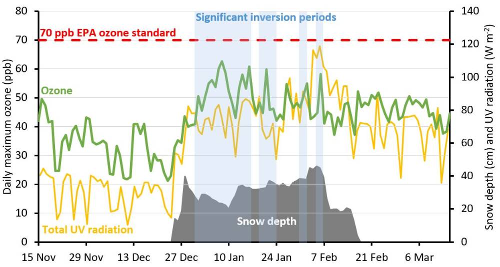
Ouray 8-hour average ozone, along with snow depth and total daytime UV radiation (incoming + outgoing UV-A and UV-B) measured at Horsepool. Inversion periods (calculated as days when daytime temperature at Ouray was at least 5°C colder than daytime temperature at Fruitland) are shown as blue shading.
Team News
- Funding from Utah Legislature: Representative Scott Chew sponsored an $200,000 appropriation during the recent 2020 session of the Utah Legislature to provide additional funding for our team's winter ozone research. Thanks to work done by Representative Chew and many other friends and partners, the appropriation passed! We are so grateful to Representative Chew and others who worked on this.
- Utah Clean Air Partnership Person of the Year Award: Seth Lyman received the UCAIR Person of the Year award in February. Seth had this to say about the award: “The air quality issues the Uintah Basin faces are complex, and the progress we have made is the result of dedicated effort by many different partners. Credit belongs to my coworkers at the Bingham Center, as well as local oil and gas companies, elected officials, government agencies, the Ute Tribe, and environmental advocates.” Learn more by clicking the link on our news feed, or watch a video about the award.
- Undergraduate researcher Makenzie Holmes presents research at Capitol Hill: Makenzie Holmes, a USU-Uintah Basin undergraduate working as a researcher in our group, who is also an Anadarko Student Research Fellowship recipient, was one of only six researchers chosen by the USU College of Science to present her work at the Utah State Capitol in February. Makenzie is also the recipient of the 2019 USU-Uintah Basin Student Researcher of the Year Award. Read more about these honors on the USU news website.
- Seth Lyman and Huy Tran receive NSF award to study atmospheric mercury: In February Seth Lyman and Huy Tran received a $480,000, 3-year award from the National Science Foundation. The award is part of a collaborative project with Colorado College, the University of Colorado, and the University of Utah to improve scientific understanding of atmospheric mercury chemistry. Seth has developed new instrumentation that allows for accurate measurements of oxidized mercury in the ambient atmosphere at levels in the low parts-per-quadrillion range. Seth, Trevor O'Neil, and student Tyler Elgiar will deploy these instruments at Storm Peak, a measurement station atop the Steamboat Springs ski resort, and Huy will develop a photochemical model to better understand mercury transport and chemistry. Mercury in the atmosphere is not a unique problem to our region, and oil and gas production is not a significant source of mercury. Global anthropogenic and natural sources emit mercury, and it can be transported across continents before depositing to ecosystems and impacting health and the environment.
- New website for Uinta Basin Ozone Working Group: The Uinta Basin Ozone Working Group has a new website, https://basinozonegroup.usu.edu. Visit the website for meeting dates and times, agendas, and other critical information.
Ambient Organic Compound Measurements will be Used to Improve Emissions Inventories and Model Performance
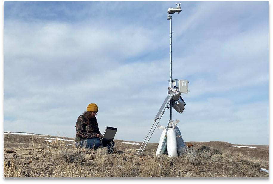
During fall 2019, we built 17 tripods (pictured at right) that can be programmed to collect simultaneous air samples with funding from Utah DAQ, the Utah Legislature, and UIMSSD. We deployed these tripods in configurations across the Basin during winter 2020 and analyzed the samples in our lab for concentrations of a suite of 70 non-methane hydrocarbons, alcohols, and carbonyls (e.g., formaldehyde, acetaldehyde, etc.). We completed wintertime data collection in February and have made all collected data available on our website.
Similar to preliminary deployments we conducted during winter 2019, alkene concentrations were higher in the western Uinta Basin during winter 2020 (see figure below). Alkenes are extremely reactive, and large alkene sources can be expected to be important contributors to wintertime ozone production. As detailed in Section 5 of our 2019 Annual Report, we believe natural gas-fueled engines are a large source of these alkenes. Also, some of the samples we collected in February 2020, when no inversion was present, had high concentrations of methanol (greater than 50% of total non-methane organics in a few cases), and we are working to understand the sources of methanol in these samples. We didn’t find a clear difference in the organic compound composition in areas with well-site glycol dehydrators versus areas without dehydrators.
In a related project, we measured concentrations of glycols (ethylene glycol, propylene glycol, etc.) at our Seven Sisters monitoring station, which is near a large number of glycol dehydrators. Glycols are relatively reactive ozone precursors, and we suspected that high concentrations of glycols may exist in the area (no one had attempted to measure them in the Basin atmosphere before). In all of our measurements, however, glycol concentrations were below detection limits (2-8 ppb), showing that the are not important ozone precursors in the Uinta Basin.
The next step in this work is to compare these ambient measurements to inventory-based model results to see how well the model predicts measured concentrations, and to explore ways to improve model performance.
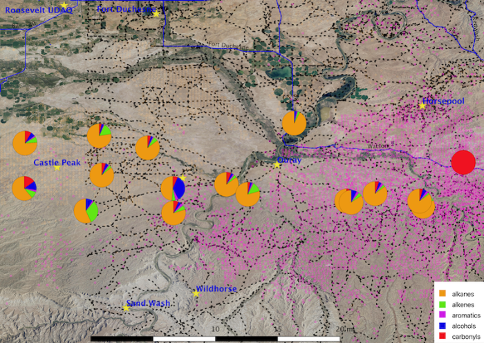
Map showing locations of organic compounds sampled on 10 January 2020 (22:00 start time; six-hour sample). Pie charts show the percent-by-volume of the different compound groups indicated. Pink dots in the figure are gas wells, and the faint orange dots are oil wells. the dotted black lines are roads. The red circle at right is an error.
Incorporation of Satellite Data Improves Air Quality Model Performance
With funding from Utah DAQ and the Utah Legislature, we are investigating methods to assimilate Moderate Resolution Imaging Spectroradiometer (MODIS) land surface data products (surface albedo, snow cover, and vegetation fraction) into meteorology and photochemistry models (we use the WRF model for meteorology and the CAMx model for chemistry and transport). These land surface characteristics ultimately drive the energy balances and transfers and air pollutant deposition in models. The traditional WRF and CAMx models apply long-term average climatological values of land surface characteristics, and these are often outdated and inaccurately estimated due WRF’s underperformance with respect to other quantities, including snow depth. In contrast, satellite data assimilation techniques provide instant and realistic observations of these characteristics. In earlier air quality modeling exercises for winter episodes, we had to manually correct the simulated snow depth of the entire Uinta Basin based on limited point observations in order to obtain adequate surface albedo, which is important for ozone formation. To overcome this limitation and accommodate MODIS data assimilation, we modified several WRF and CAMx source codes.
Our preliminary results show that, while assimilating MODIS data into our models provides an accurate representation of surface albedo and vegetation cover (see figure below), this does not necessarily translate to better ozone performance in comparison to earlier modeling exercises. This is because ozone performance is far more sensitive to emissions than to meteorological inputs. Furthermore, prior to MODIS data assimilation, we also applied other observational data assimilation techniques which have greatly improved WRF model performance. Regardless, we consider MODIS data assimilation as a significant step up from earlier manual and arbitrary corrections that had to be made to the model.
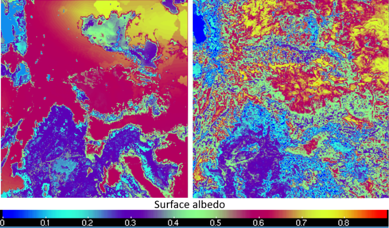
Comparison of surface albedo as simulated by WRF where no correction was applied (left) and with MODIS data assimilation (right) for an episode during winter 2011.
In future work, we will examine methane and nitrogen dioxide data from the TROPOspheric Monitoring Instrument (TROPOMI) satellite, in cooperation with ground-based measurements, for the purpose of developing a top-down emissions inventory for organic compounds and oxides of nitrogen in the Uintah Basin. This top-down emissions inventory will serve as a way to "ground-truth" regulatory oil and gas emission inventories.
Modeling Updates
We have funding from BLM to update air quality modeling for their Air Resource Management Strategy (ARMS). We have completed meteorological and chemical modeling for the base-case scenario (year 2011), and we are finishing emissions processing and chemical simulations for future scenarios (year 2025). We expect our project final report to be available by the end of July. Some key findings thus far include:
- The meteorological model showed good performance for annual, seasonal, and state-wide averages in terms of predicting conventional meteorological quantities such as surface temperature, humidity and wind in Utah. The model was able to reproduce the timing of inversion starts and ends, cloudiness, and the radiation budget for Uinta Basin winter conditions.
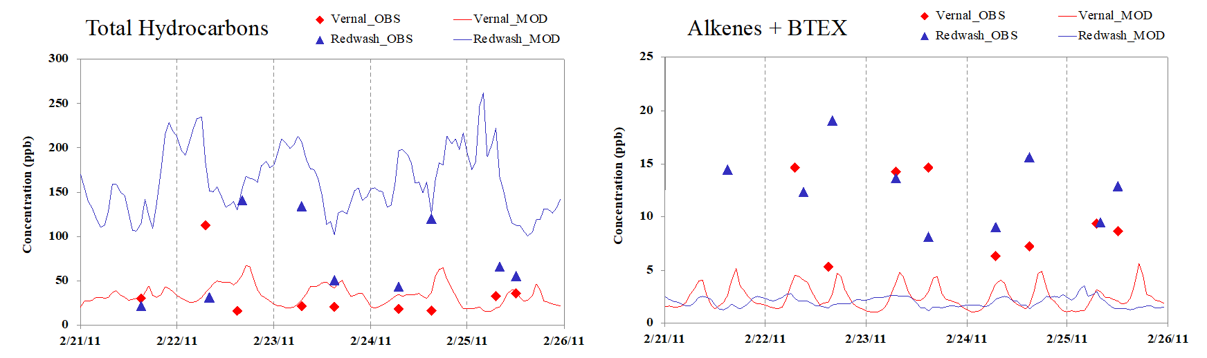
- The chemical model yielded good performance for annual, seasonal, and state-wide averages in terms of predicting ozone and particulate matter in Utah, but it failed to capture elevated ozone and particulate matter in the Uinta Basin during winter inversion episodes. Results indicated that, while the emissions inventory gave reasonable total organic compound emissions, its emissions of reactive organics (e.g., alkenes, aromatics, and carbonyls) were much too low (see the figure below), and this is likely the reason the model underestimated wintertime ozone. Additional work is needed to improve estimates of organic compound emissions composition from the Uinta Basin oil and gas industry.
With funding from the Utah Legislature and UIMSSD, we simulated Uinta Basin wintertime ozone using version 3.9 of the WRF-Chem model with the RACM and CB05 chemical mechanisms. Chemical mechanisms contain the chemical reactions and reaction rates that the model uses to simulate atmospheric chemistry. In our simulations, the RACM mechanism was able to reproduce elevated wintertime ozone in the Uinta Basin, but simulations with the CB05 mechanism produced much lower ozone (see figure below). The WRF-Chem model was configured nearly identically for both of these tests, so the difference in outcome must have been due to some difference between the two chemical mechanisms. We aren't yet sure why these mechanisms yielded such different behavior.
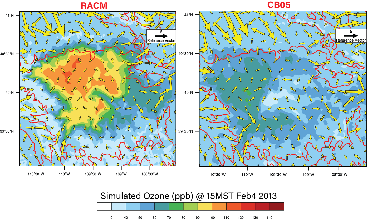
Uinta Basin ozone concentrations simulated by RACM (left) versus CB05 (right) using the WRF-Chem model.
New Tool Provides Measurement-Based Emissions Estimates for Produced Water Ponds
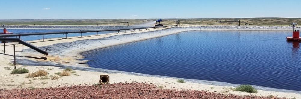
Oil and natural gas deposits almost always occur in conjunction with subterranean water that comes to the surface when drilling for oil or natural gas. Because this “produced water” is fouled with organic compounds it cannot be released directly into the hydrosphere. One treatment method is to discharge the produced water into treatment ponds from which it is allowed to evaporate. However, the entrained organic compounds also evaporate, meaning that these ponds are a source of organic compound emissions. These emissions are a health hazard and can also act as ozone precursors, but until recently, no one had bothered to measure the organic compound emission rates.
From 2015 to 2017, the Bingham Research Center, in partnership with GSI Environmental Inc., an environmental consulting firm located in Austin, Texas, and under contract from the Air Quality Division of the Wyoming Department of Environmental Quality, measured atmospheric emissions and water quality at several pond facilities throughout the State of Wyoming. Then under a second project completed December 2019, again in partnership with GSI, we developed a mathematical model (the Wyoming Pond Emissions Calculator, or WyPEC) designed to be consistent with the dataset obtained previously. The final model has been packaged in a user-friendly Excel spreadsheet. Pond operators and governmental regulators can plug into WyPEC a few data points, such as the average monthly wind speed and temperature, water quality data, pond surface area, etc., and obtain monthly estimates of the emissions of a suite of organics, including alkanes, aromatics, and alcohols.
The project entailed comparing the field data against a number of different existing models with the plan to select the model with the best performance. However, as it turned out, no single model worked well across the full dataset, and the final version of WyPEC was constructed as a hybrid, combining the strengths of two of these models, along with several additional tweaks developed by us or by GSI.
The Wyoming Air Quality Division plans to use WyPEC to characterize organic compound emissions from all produced water ponds in the state, and the tool can be downloaded for free from our website or Wyoming DEQ's website (to view the latest WDEQ uploads, the document list must be sorted by date).
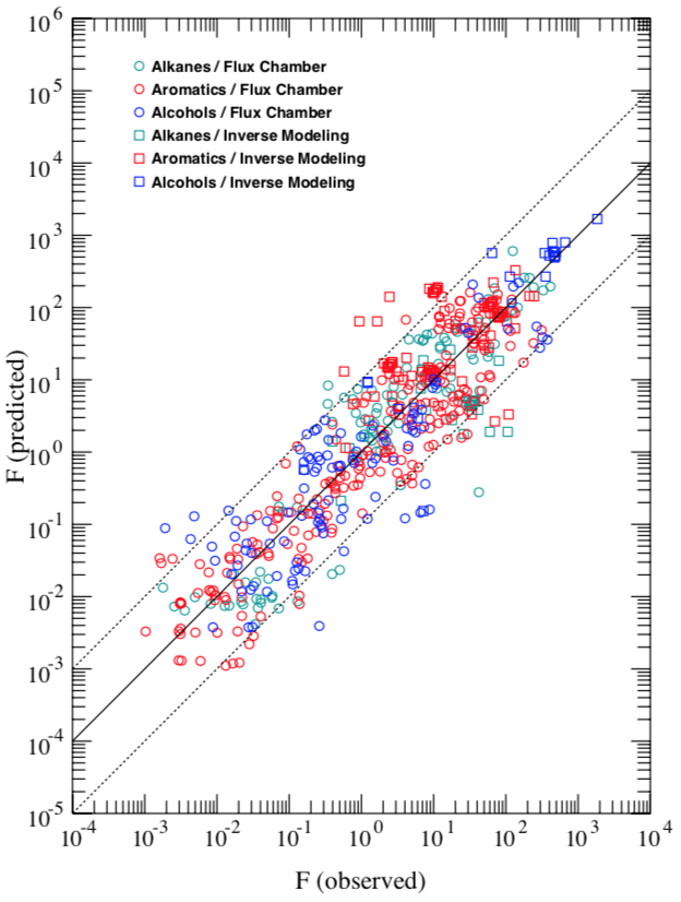
Comparison between observed pond emissions and the emissions predicted by WyPEC. Agreement is to within about an order of magnitude over six orders of magnitude in the emission.
Coming Up Next
- Bingham Center scientists are wrapping up BLM ARMS modeling, including projections of the impact of future oil and gas development on Utah air quality. The final report of that work will be available this summer.
- We are currently compiling and analyzing data we collected this winter at our permanent monitoring stations and our portable sample collection tripods. Our next newsletter will contain more information about what we found this winter.
- Utah DAQ will release the final report of the Uinta Basin Composition Study very soon. This study, which the Bingham Center team participated in, provided new measurements of the organic compound composition of emissions from oil and natural gas wells in the Uinta Basin.