
Numerical Simulations of the Uinta Basin
A recent project looks at the meteorology, rather than the chemistry, of poorly simulated high-ozone cases like January 2013. The goal is to create a more faithful depiction of the atmosphere around the Basin - especially the creation of persistent cold-air pools (inversion)- to hand off for air-chemistry simulations.
John Lawson and Michael Davies
Project Ongoing
Funding: Utah Legislature, Uintah Co., SSD1
Project Updates
Updated October 2026
- Recent Developments:
- Our paper is now published in the journal Air (October 2026): https://doi.org/10.3390/air4040025. It shows that simulations of cold-air pools (inversions) in the Basin depend strongly on the national or global weather data used to start them. This matters because an air-chemistry model can only reproduce the Basin’s highest ozone if the weather model first gets the cold-air pool right.
- The errors between these initial datasets can be as large as the error correction from field experiments with tethersondes (weather balloons on a wire).
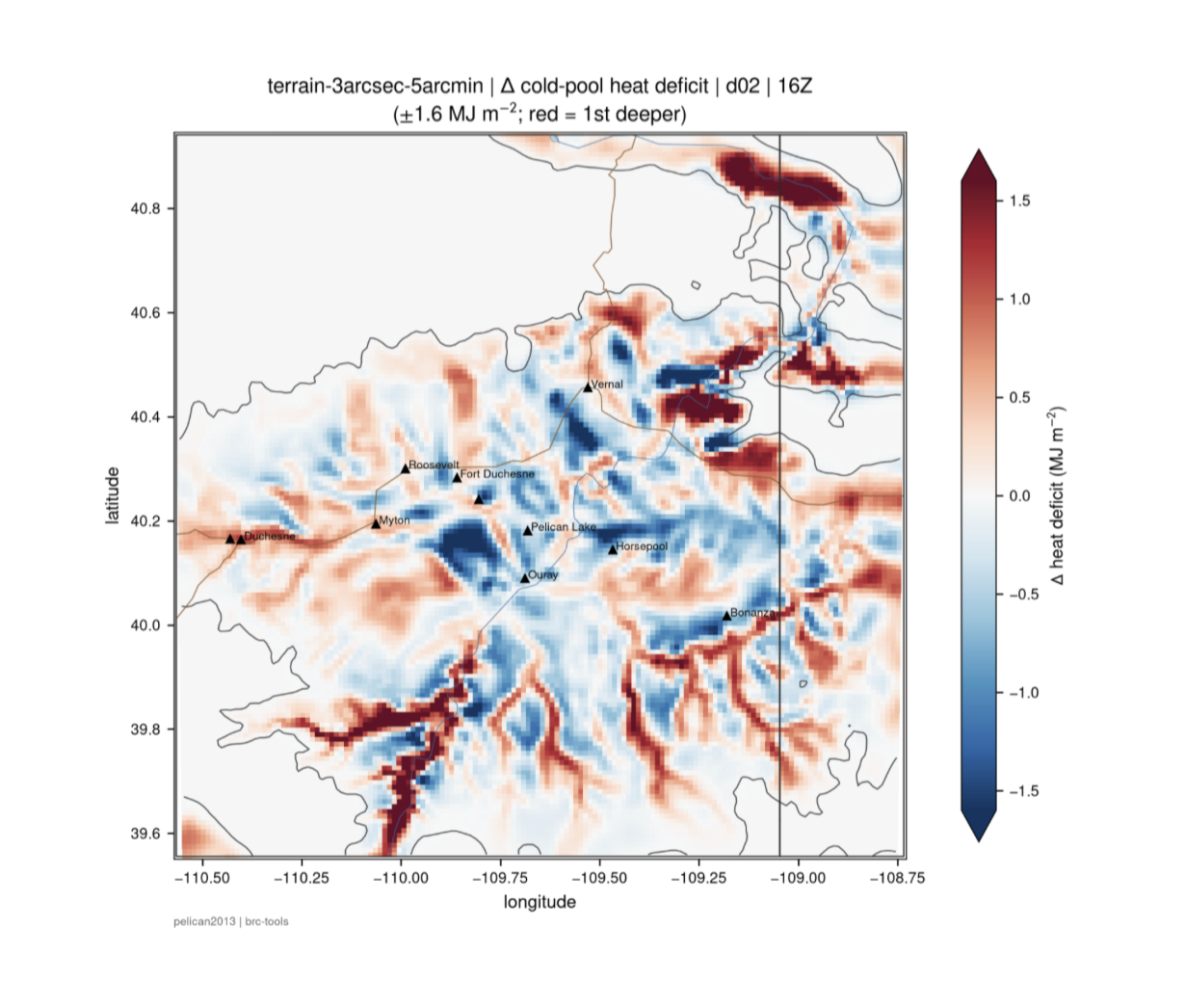
- We found smoother terrain and valley makes for colder temperatures, but the volume of cold air is smaller than when we use high-detail terrain. When the model can "see" more fine details, valleys can become "reservoirs" for cold air. This drains more slowly into the Basin with more bumps and valleys obstructing the sinking cold air. This may make the inversion appear less severe as surface temperature at the Basin's weather stations, but potentially the cold air fills a larger volume.
- Our paper is now published in the journal Air (October 2026): https://doi.org/10.3390/air4040025. It shows that simulations of cold-air pools (inversions) in the Basin depend strongly on the national or global weather data used to start them. This matters because an air-chemistry model can only reproduce the Basin’s highest ozone if the weather model first gets the cold-air pool right.
- Current and upcoming work:
- How much better can we do simulations with 2026 datasets? This includes the US-wide initial weather datasets, different ways of configuring the weather model, and how to trade off between uncertainty (running many slightly different models to see what might happen) and resolution (seeing more of the fine-scale flow around mountain canyons).
- Linking this work to air chemistry: can we create a better initial state of key ozone events than what exists already?
- Next study: cold air that drains out of mountain canyons into the Basin. We will compare the WRF weather model with a simpler physics model and with machine learning, and are preparing a proposal with the Utah Climate Center. Knowing how canyons feed the Basin’s cold-air pool, and how small ‘reservoirs’ of cold air can be missed by a weather model on a coarse grid, could help explain why some inversions last long enough to build high ozone.
- How much better can we do simulations with 2026 datasets? This includes the US-wide initial weather datasets, different ways of configuring the weather model, and how to trade off between uncertainty (running many slightly different models to see what might happen) and resolution (seeing more of the fine-scale flow around mountain canyons).
- Problems:
- No problems to report.
- No problems to report.
- Image:
- We ran two simulations that created a cold pool: one with coarse, smooth terrain (mountains, valleys), and another that was detailed. We subtraccted subtracted the differences in cold-pool strength. The image shows wher where the biggest differences occurred in a stronger cold pool by increasing detail of the mountainous terrain: red means the cold pool is stronger for the high-resolution detail (blue is stronger cold pool for smoother terrain). We see around sunrise here that cold air has pooled faster when terrain is smooth (blue colours colors at the Basin floor) but there are “Reservoirs” of cold air that appear deep red in the (more detailed) canyons and valleys.