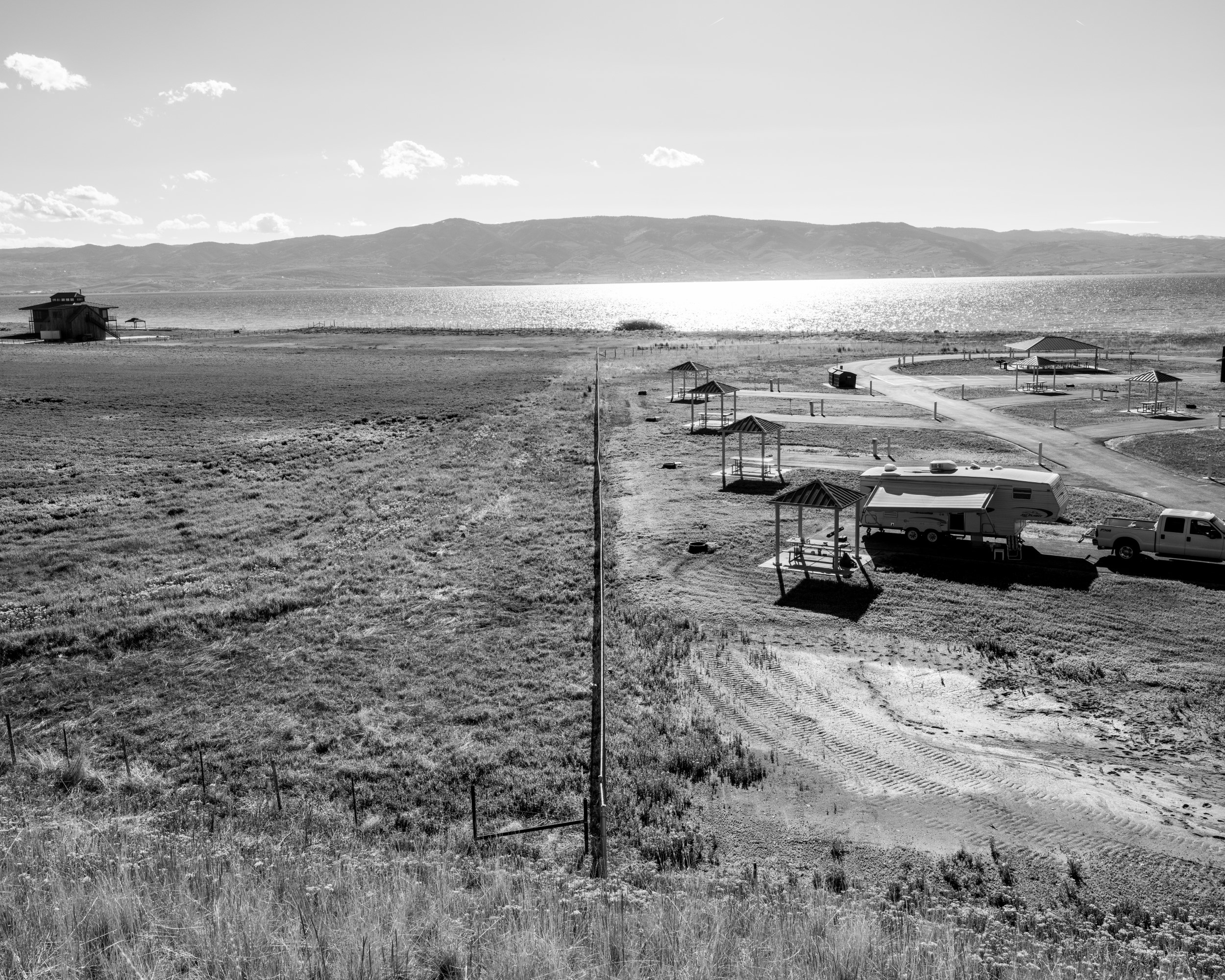
Bear Lake is unique in the region as one of just three large natural lakes in Utah. Over the past decade, visitation to Bear Lake, located on the Idaho-Utah border, has surged by 300% and amplified concerns over development, water management, and environmental sustainability. This has created unique challenges for the lake and those who maintain the land.
The Bear Lake Needs Assessment Documentation and Visualization Project blends scientific research with visual storytelling to raise awareness of critical issues surrounding Bear Lake's natural resources, land use, and human impact. The project is one of ten Bear Lake Needs Assessment research projects funded by grants from the Utah Division of Forestry, Fire and State Lands and administered by USU's Institute for Land, Water and Air.
The project is developed from a range of photographic traditions, including early geological survey photographs made in the American West in the 1870s, the sublime Western landscapes captured by Group f/64 in the mid-twentieth century, and the politically charged New Topographies movement of the 1970s. The project is also inspired by more contemporary photographic approaches, particularly those by artists working in recent documentary traditions in which personal perspectives, political points of view, and visual poetics inform lyrically driven photographs and non-linear image sequences.

Bear Lake, Utah.
Bear Lake is unique in the region as one of just three large natural lakes in Utah. Over the past decade, visitation to Bear Lake, located on the Idaho-Utah border, has surged by 300% and amplified concerns over development, water management, and environmental sustainability.
In a 2024 interview with researchers from the USU sociology department to discuss local perspectives about Bear Lake, a resident reported, "When everything else is crazy, the one thing that keeps me smiling is seeing the deer, seeing the vegetation, and seeing the lake. It's the one constant that we all have."
Photo by Jared Ragland
Andrew Stokes, Idaho State Parks & Recreation Park Manager, Bear Lake State Park East Beach, Idaho.
Andy Stokes was raised by a single mother and although the family often struggled to make ends meet, Andy's mother dedicated time and resources each summer to take Andy and his five brothers to Bear Lake for vacation and eventually purchase a trailer on the lake. The memories they made each summer inspired Andy to join the Idaho State Park service. "I realized I wanted others to have the same experiences I had," Stokes said. "And I see great memories made here every day."
Photo by Jared Ragland

Home Town Drive-In, Garden City, Utah, Labor Day, 2024.
In 2021, visitors to Bear Lake contributed approximately $48 million to the local economy, yet increased visitor numbers can strain local infrastructure, leading to overcrowded beaches and environmental concerns such as littering and habitat disruption. Local authorities and communities are working to balance the economic benefits of tourism with the need to preserve Bear Lake's natural beauty and ensure a sustainable future for the region.
Photo by Jared Ragland


A family gathers for a barbecue on July 4, 2024 at Hunters Point Beach, Utah.
Each summer Bear Lake transforms from a tranquil area with a modest year-round population to a bustling tourist destination. Rich County, Utah, which surrounds part of Bear Lake, has a permanent population of approximately 2,500 residents. However, in the summer months more than 40,000 people visit the region each weekend, with the number of tourists rapidly increasing in recent years.
Photo by Lele Bonizzi

Bear Lake State Park Marina, Garden City, Utah.
Located on Bear Lake's western shore in Garden City, Utah, Bear Lake State Park Marina is a bustling launch point for boating and water recreation, especially during peak summer season. The marina moors approximately 369 boats on a seasonal basis, from May 1 to October 31i, and features a seven-lane boat launch, 21 transient slips, and rental options for everything from boats to jet skis. During peak months the marina sees high demand, with a waiting list that can range from two to ten years.
Photo by Lele Bonizzi

Bear Lake State Park, Garden City, Utah.
Bear Lake State Park is divided into four main areas: the Marina in Garden City, Rendezvous Beach on the lake's southern end, North Beach on the most-northern Idaho side, and the Eastside, which includes several primitive campgrounds and picnic spots. An entry pass to Bear Lake State Park provides access to each of the beaches, allowing visitors to explore the lake from multiple vantage points.
Photo by Lele Bonizzi

Bear Lake, Utah.
Photo by Jared Ragland

Seven Mile Ranch Community development construction, near St. Charles, Idaho.
Located seven miles north of the Utah/Idaho state line and advertised as a residential community that "represents a rare opportunity to reimagine the quintessential Bear Lake experience" through "world-class amenities;" Seven Mile Ranch will bring more than 140 luxury homes along nearly a mile of prime undisturbed Bear Lake shoreline. The development promises newly formed private lakes and water access points for homeowners. In the first phase of development, prices for 1/4-1/2 acre lots range from $300,000 to $1.2 million
Photo by Jared Ragland
Realtor and real estate developer Gary Mckee at his home in the gated community of Eden Ranch on Bear Lake's eastern shore near Laketown, Utah.
For several decades Mckee has played a key role in the development of Bear Lake and is a leading figure in several luxury housing developments around the lake. As demand for real estate skyrockets around the lake, the influx of luxury developments has impacted affordability for local residents. In Bear Lake County, Idaho, the median home price is approximately $1.3 million.
Photo by Jared Ragland

Adjoining residential, agricultural, and recreational land along North Cisco Road on the eastern shore of Bear Lake.
In 2024, the Social & Community Dimensions of Natural Resources class at USU, directed by USU College of Humanities and Social Sciences faculty Dr. Betsy Brunner, Dr. Jessica Schad, and Dr. Stacia Ryder conducted community member interviews to hear perspective on the issues that are most important to Bear Lake part- and full-time residents.
While year-round opportunities for outdoor recreation were frequently mentioned as a source for wellbeing for residents, one anonymous resident reported, "In my opinion, they're trying to make it kind of like Park City or Jackson Hole, that kind of thing. And they're going to end up pricing the locals right out of existence. Because that's what happened in those two places."
Photo by Jared Ragland

Jose (last name withheld by request), a contractor, works at an under-construction luxury home at The Reserve at Bear Lake in Fish Haven, Idaho.
Located on 750 acres in Fish Haven, Idaho, The Reserve at Bear Lake is a private, gated community that provides residents private beach access, pools, hot tubs, a fitness clubhouse, athletic courts, golf courses, playgrounds, and hiking—all under the slogan, "Your Luxury Home Away from Home." Recent home prices at The Reserve are listed between $1.3-2.6 million.
Photo by Lele Bonizzi

Irrigated farmland along the west shore of Bear Lake near Fish Haven, Idaho.
Agriculture is a major contributor to the local economy of Bear Lake County, Idaho. According to the 2017 Census of Agriculture by the national Agricultural Statistics Service (USDA), the county had 395 farms covering nearly 270,000 acres. The region's high altitude and short growing season influence the types of crops cultivated, with wheat, barley, oats, alfalfa, and wild hay the most predominant. On the Utah side, Rich County's agricultural sector is similarly vital. The region's rangelands provide ample grazing opportunities for cattle and sheep and contributes to the county's status as a leading livestock producer in Utah.
However, the region's agriculture faces challenges, including water resource management and the impact of invasive species, such as Eurasian Watermilfoil, which has raised concerns among local farmers and ranchers as water quality and availability is negatively impacted.
Photo by Jared Ragland

Brady Long, Executive Director of Bear Lake Watch, at his home on the east shore of Bear Lake, Bear Lake County, Idaho.
Since 1993, Bear Lake Watch has united ordinary citizens in extraordinary work to protect the "Caribbean of the Rockies." As a nonprofit, the organization champions sustainable lake management, addressing critical issues like invasive species, water quality, and sediment control. Long has been a vital force behind the Bear Lake Watch mission, using his leadership to drive initiatives that keep Bear Lake "clean, deep, and blue." His commitment to Bear Lake's health unites science, community, and policy for sustainable conservation.
Photo by Lele Bonizzi

Claudia and David Cottle, founding members of Bear Lake Watch, at their home in Fish Haven, Idaho.
Through collaboration with scientists, communities, and policymakers, Bear Lake Watch advocates for science-driven solutions and responsible recreation. The Cottles have played a crucial role in Bear Lake Watch's history, and their early leadership laid the foundation for the organization's ongoing dedication to safeguarding Bear Lake's beauty and ecology for future generations.
Photo by Lele Bonizzi

Jim Kimball looks out at Bear Lake from his home on the eastern shore in Bear Lake County, Idaho.
"I don't go to church," Kimball said, "but when I get up in the morning, I look out here and God is with me" After working as a fish and wildlife officer across the American West, including a stint as Forest Supervisor at Tongass National Forest in Alaska, Kimball moved his family to Bountiful, Utah and would regularly visit Bear Lake. He soon bought property at Emerald Beach on the western shore and became involved with the community.
Historically, Bear Lake water levels have been controlled by electric power company PacifiCorp. In the mid 1990's as drought and irrigation usage brought lake levels to two feet of its record low, Kimball helped lead a coalition of community stakeholders, environmental activist groups, and agricultural irrigation interests across Utah and Idaho to file a lawsuit to define and manage PacifiCorp's control of fluctuating lake levels. The various interest groups all came to the table to work out agreed solutions, and a result the Bear Lake Settlement Agreement was executed on April 10, 1995. The agreement recognized the need for water allocation in the lake while also authorizing an irrigation allocation schedule and determining that any unused water storage allocation would be preserved for Bear Lake recovery for future use.
Photo by Jared Ragland
Near Fish Haven, Idaho, where families have farmed and raised livestock on Bear Lake for generations.
Several local families trace their lineage back to the first Mormon settlers who arrived in the region in the 1860's. Despite years of successful farming, ranchers are painting a dim picture for the future of sustainable agriculture in Bear Lake, particularly as herding and grazing land is sold to developers. "The development is like an invasive species-it affects every aspect of ranching and life," a longtime farmer said. "But I'm obligated until I die to take care of (the land)."
Photo by Jared Ragland


Bear Lake County, Idaho, where families have farmed and ranched on Bear Lake for generations.
Several local families trace their lineage back to the first Mormon settlers who arrived in the region in the 1860's.
Photo by Jared Ragland

A water sample is drawn from Bear Lake near Lifton Pumping station, Idaho.
A team of USU environmental scientists led by Assistant Professor Yiming Su, Ph.D., studied the samples to detect and quantify nanoparticle contamination and determine how human activity on or near the lake and seasonal changes affects contamination concentrations. The study found that micro-/nanoplastic contamination is significant around the entirety of the lake, and plastic waste management around lake is recommended.
Photo by Jared Ragland

USU Civil and Environmental Engineering scientist Junjie Tang collects water samples at Bear Lake State Park—North Beach, Idaho.
The water samples, drawn from one of six sites around Bear Lake by a team led by Assistant Professor Yiming Su, Ph.D., were used to detect and quantify nanoparticle contamination and how human activity on or near the lake and seasonal changes affects concentrations. According to the study, nanoparticle pollution—including higher concentration levels of Zinc and Copper—rises during summer months as boating and use of personal care products like sunscreen increases.
Photo by Jared Ragland

USU Assistant Professor of Computer Science and DIRECT Lab founder Mario Harper, Ph.D., and Ph.D. candidate Kobra Bohlourihajar launch the advanced Blue ROV 2 autonomous submarine robotic system at Hunters Point Beach at Bear Lake, Utah.
The Blue ROV 2 submarine was used to study the underwater environment of the lake and generate detailed longitudinal maps, sample fishery health, assess shoreline degradation, and evaluate underwater infrastructure integrity. USU's DIRECT Lab, founded by Dr. Harper, strives to expand and unite research in applied AI.
Photo by Jared Ragland

USU undergraduate Computer Science students monitor the advanced Blue ROV 2 autonomous submarine robotic system at Hunters Point Beach, Utah.
With the ROV2 drone submarine, computer scientists can develop algorithms for simultaneous localization and mapping in low-visibility underwater conditions with the goal of improving navigation and environmental monitoring.
Photo by Jared Ragland

USU Plant Sciences Ph.D. student Olanrewaju Adeyemi harvests Eurasian Watermilfoil samples at the USU Research Greenhouse in Logan, Utah.
Adeyemi was part of a research team directed by USU Assistant Professor of Weed Science Mirella Ortiz, Ph.D., to study how Bear Lake chemistry affects Eurasian Watermilfoil growth and herbicide efficacy. Eurasian Watermilfoil is a fast growing, invasive aquatic plant that poses a significant environmental and economic threat to Bear Lake. Watermilfoil was first seen in Bear Lake in 2019, and since then large clusters of the plant now cover 10% of the eastern and western shores of the lake.
Photo by Jared Ragland

USU Assistant Professor of Weed Science Mirella Ortiz, Ph.D., directs USU Agriculture students in measuring Eurasian Watermilfoil samples at the USU Research Greenhouse in Logan, Utah.
Eurasian Watermilfoil is an invasive aquatic plant and poses a significant threat as the lake's unique, mineral rich water creates a conducive habitat for prolific growth. Dr. Ortiz's team studied how herbicide behavior differs in Bear Lake's water chemistry compared to other water sources, and how the difference can impact Eurasian Watermilfoil growth in the lake.
Photo by Jared Ragland


Eurasian Watermilfoil samples, reproduced in cyanotype.
Cyanotype is an early photographic process by which objects are placed on paper coated with a solution of iron salts and exposed to UV light. The resulting image presents a "blueprint" outline of the object over deep Prussian blue. The cyanotype process was invented in 1842 and adopted by botanist/artist Anna Atkins to create albums of botanical specimens. Her work would lead to the creation of the first photographically illustrated book, Photographs of British Algae: Cyanotype Impressions, 1843-53. According to the Metropolitan Museum of Art, artistic expression was not Atkins' primary goal, yet she "was sensitive to the visual appeal of these 'flowers of the sea' and arranged her specimens on the page in imaginative and elegant compositions.
Likewise, Annora Madden's cyanotypes of the highly invasive Eurasian Watermilfoil capture the complexities of the plant's structure and the innate beauty despite the species' significant environmental and economic threat to Bear Lake, while the Prussian blue of the cyanotype mirrors the deep blue hues of the lake.
Cyanotypes by Annora Madden


Fishing net, North Eden Creek, Utah.
Throughout 2024 a USU Watershed Sciences team has examined historical and contemporary data of stream conditions, fish habitat, and fish distribution to assess the impact of restoration actions reconnecting Bear Lake tributaries, particularly North Eden Creek, to the lake. The Watershed Sciences team consisted of: USU Assistant Professor Timothy Walsworth, Ph.D.; USU Professor and U.S. Geological Society Unit Leader Phaedra Budy, Ph.D.; Jim DeRito, Bear River Program Director, Trout Unlimited; and USU Watershed Sciences graduate student Tyler Coleman.
Photo by Jared Ragland
Eastern Brook Trout, North Eden Creek, Utah.
Eastern Brook Trout were introduced to North Eden Canyon in the mid 1940's for sport fishing, however there was little understanding of what impact the species may cause throughout the watershed. Although they were last stocked in 1962, the Brook Trout have survived in the harsh conditions of the creek while preying upon and outcompeting native cutthroat trout for food and habitat.
Photo by Jared Ragland


USU Watershed Sciences graduate student Tyler Coleman conducts field work to study fish habitat at North Eden Creek, Utah.
North Eden Creek is a tributary to Bear Lake that has been disconnected from upstream migration of native cutthroat trout for more than 80 years while agricultural irrigation, reservoir construction and dam failure, mining, and extensive cattle grazing have negatively impacted North Eden Canyon's fish habitats.
Photo by Jared Ragland

USU Watershed Sciences graduate student Tyler Coleman, top left, measures a cutthroat trout during field research near the headwaters of North Eden Creek, Utah.
While North Eden Creek has been disconnected from upstream migration of cutthroat trout from Bear Lake for more than 80 years, the cutthroat remains resilient, despite the negative impact of invasive species, agricultural irrigation, reservoir construction and dam failure, mining, and extensive cattle grazing have had on local fish habitats. Scientists are optimistic that their research will aid in population growth and increased biodiversity and assist in the reclamation of the watershed.
Photo by Jared Ragland
Incisized stream bank, North Eden Creek, Utah.
In 1979 a dam failure on North Eden Creek, Utah displaced large amounts of soil and material downstream. Today, a 10-foot wall of eroded material remains and has displaced stream side vegetation, contributes to harmful erosion, and disconnects the stream from the water table in the valley.
Photo by Anastasia Coleman


Culvert under N. Cisco Road, North Eden Creek, Utah.
Installed in 1945 during a road improvement project, the N. Cisco Road culvert has prevented cutthroat trout from accessing important spawning habitat for 80 years. A relic population of cutthroat have since been isolated in the headwaters of North Eden Creek.
Photo by Anastasia Coleman
Remnants of an irrigation dam, North Eden Creek, Utah.
Farmers in North Eden Canyon routinely use makeshift dams to divert water for irrigation, potentially dewatering the creek below and endangering fish that find their way into temporary diversion streams.
Photo by Anastasia Coleman

Stewart Dam, Bear Lake County, Idaho.
Located on the Bear River approximately five miles south of Montpelier, Idaho, Stewart Dam is a 200' long, 75' wide concrete and steel structure with six manual radial gates that was constructed between 1909-1918 for irrigation and flood control. Currently operated by PacifiCorp, the dam diverts the Bear River and channels water to Bear Lake through a series of canals and wetlands.
Photo by Jared Ragland

A map showing the course of water flow through the Bear Lake watershed hangs above the visitor's log at Lifton Pump Station, St. Charles, Idaho.
After being harnessed at the Stewart Dam, water from the Bear River is diverted through the Rainbow Inlet Canal and into Mud Lake, then into Bear Lake via sluice gates and causeway structures. After being stored in Bear Lake, water is pumped through Lifton and returned to the Bear River via the Bear Lake Outlet Canal, where it flows downstream through Idaho and Utah during irrigation season.
Photo by Jared Ragland

Lifton Pump Station, St. Charles, Idaho.
Lifton Pump Station, located four miles east of St. Charles, Idaho, was constructed between 1909-1918 for irrigation and flood control. With five electric pumps, each rated at 750 horsepower, the Lifton Pump Station moves water from Bear Lake to Mud Lake for irrigational use on farms in Idaho and Utah.
Photo by Jared Ragland
Jess Johnson, Lifton Pump Station Operator.
Jess Johnson has operated the Lifton Pump Station for 40 years. He also serves as two-time mayor of St. Charles, Idaho. While Bear Lake is known for its crystal blue water and beaches, it's the surrounding hills that Johnson loves most about the area. "There's no place like them," he said. But with the influx of seasonal visitors, Johnson is concerned—especially as increased off-road vehicle use on trails and unpaved roads deepen ruts and degrade conditions. "You can't even drive up there now and keep your false teeth in your mouth," he said.
Photo by Jared Ragland


Bear Lake Outlet Canal, Idaho.
At 150 feet wide and 14 miles long, the Bear Lake Outlet Canal moves water from Bear Lake at the Lifton Pump Station to the downstream section of the Bear River. The Outlet Canal and Rainbow Inlet Canal are each situated within the Dingle Swamp and Bear Lake National Wildlife Refuge. Established in 1968 to protect and manage habitat for waterfowl and other migratory birds, the refuge encompasses 18,000 acres of cattail marsh, open water, and flooded meadows that are managed by the U.S. Fish and Wildlife Service. The refuge provides valuable habitat for waterfowl and colonial nesting water birds.
Photo by Jared Ragland


Roads and trails, Swan Flats, Utah.
A series of roads and trails throughout the Swan Flats area provides vital access to scenic routes and historical sites. Located just west of Bear Lake, the area is rich in wildlife and was established as the first Utah settlement along Bear Lake in 1864. Yet the diverse ecosystem faces ongoing controversy over land use and recreational activities, particularly as increased off-road vehicle use clashes with preservation efforts.
Photos by Kennedy Fry
Hunters Nikolai Gonzalez (left) and Noah Hardman (right) process game near Swan Flat Road, west of Bear Lake.
Once a sacred gathering place for the Shoshone people, Swan Flat saw dramatic changes as early pathfinders, trappers, and settlers colonized the region in the 19th century and brought about the decline of beaver populations, introduced non-native plant species, and eradicated gray wolves. Today, Swan Flat Road serves as a vital access point for hunting and recreation, opening a historically rich area while embodying the ongoing tension between preservation and human activity.
Photo by Kennedy Fry

Student photographers and editors:
- Lele Bonizzi
- Eli Clare
- Anastasia Coleman
- Olivia Ethington
- Kennedy Fry
- Annora Madden
- Kennedy McLeod
- Kenzli Pendleton
Special thanks:
- USU's ILWA
- USU Caine College of the Arts
- Bear Lake Watch
- Prince Gallery
- Collaborators at USU and on the lake