L.1.1 Utah’s public land owners
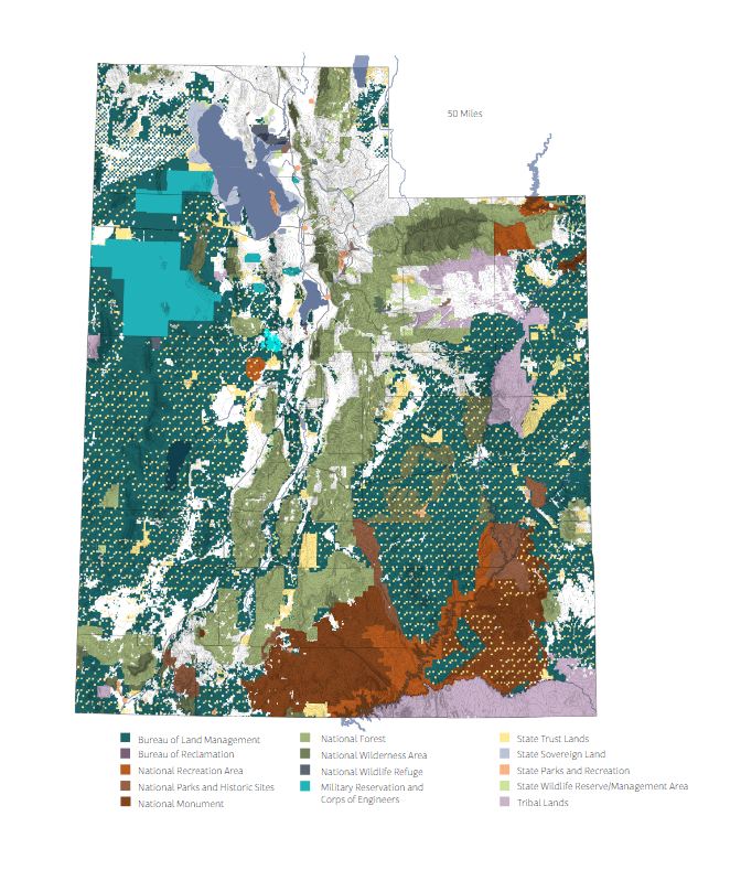
Created using land ownership data cooperatively maintained by the Bureau of Land Management and the Utah Trust Lands Administration, this map details public landowners across Utah. Private land is not colored on this map.
L.1.2 Number of operating farms and farmed acres
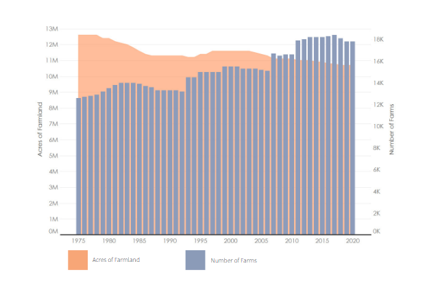
Created using data from the Utah Department of Agriculture and Food annual summary, this chart compares the number of farmed acres to the number of operating farms. This chart shows that while the number of operating farms continues to increase, agricultural land decreases
The public lands of Utah are owned and managed by several federal and state agencies. Federal public lands are owned and managed by the Bureau of Land Management, National Forest Service, National Parks Service, military institutions, etc. State public lands are managed by Utah Division of Forestry Fire and State Lands, the Utah Division of State Parks , the Utah Trust Lands Administration, and other relevant state agencies. The Utah Trust Lands Administration manages a patchwork of parcels granted to the state by the federal government at statehood with the purpose of generating revenue for public institutions, primarily schools. These lands are carefully considered for various development, extraction, renewable energy, and other projects for the best benefit to public institutions and sustainability. Different from other public lands, these areas are generally not open access and are only occasionally developed for recreational use.
Utah has a statewide legacy of productive agriculture. Examining the way we develop or maintain farmed lands, and considering who manages them is important to understanding the future of this legacy. In recent years we observe a trend of lost farmland as the number of acres held in agriculture decreases. Interestingly, this coincides with an increase in the total number of farms operating. These seemingly contrary trends indicate an increase in the number of small-scale farm operations around the state.
The following metric section highlights a variety of spatial and numeric measures of Utah’s landscape. It details wildfire history, select wildlife species’ habitat and game harvest, mining extractions, and statewide park visitation numbers.
References
- Utah Geospatial Resource Center. (2024). Utah Land Ownership. (Land ownership and Number of farms). [Data set]. UGRC. https://gis.utah.gov/products/sgid/cadastre/land-ownership/