ArcGIS Pro Introduction
This is a thorough introduction to ArcGIS Pro map and layout tools. Learn how to create projects, add data and manipulate the drawing order, change the way data is drawn on the map, and create professional map layouts.
This is a thorough introduction to ArcGIS Pro map and layout tools. Learn how to create projects, add data and manipulate the drawing order, change the way data is drawn on the map, and create professional map layouts.
Use a combination of tools to extract information from vector and raster map layers to summarize characteristics of a landscape.
Combine raster and vector map layers to identify potentially suitable habitat locations based on known habitat criteria for a species.
Basics of cartography, layout, and sharing maps
Explore the power (and countless nuances) of raster data: resolution, error, uncertainty, value attributes, and more.
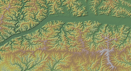
Learn about the basic raster surfaces: elevation, slope, hillshade, aspect. Use Zonal statistics to summarize raster values within defined areas.
Explore how points, lines, and polygons explicitly map our world. Utilize vast tables of attribute data associated with mapped features to quantify and summarize map features.
This exercise explores vector processing tools: Select by Attribute, Select by Location, Buffering, Clipping and more.
Create map points from a table of coordinate values. Hopefully discover the importance of spatial reference systems!
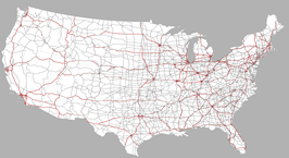
Use geoprocessing tools Create Random Points, Subset, and negative selection distances to map potential locations for 10 study sites. Use Network Analysis tools to calculate a loop route stopping at every site.
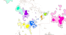
You will work through three levels of pattern analysis: locational patterns, spatial auto-correlation of locations plus an associated value, and statistically significant clusters of locations sharing high values and clusters sharing low values.
Access synthesized global climate data from the NASA GISS Surface Temperature Analysis site. Hone cartographic skills to create a professional legend communicating highly complex data.
A map series uses a series of features from a shapefile (study site polygons, river reaches, etc.) to automate creation of a series of matching map pages.
Explore the implications of resolution and elevation source material for mapping, conservation, and understanding landscapes. Demonstration of downloading elevation data from the UT AGRC and the USGS National Map.
Create a composite binary raster model (combining elevation, slope, and aspect map layers) to predict potential habitat for Mexican spotted owls.
Calculate a kernel density surface from known coyote locations. Determine 50% and 90% probability of use areas. Add landcover to estimate preference ratios.
Use elevation models to quantify drainage area to a user defined pour point. Derive a stream network and calculate stream order.
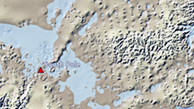
Using a sequence of raster calculations, manipulate the bedrock elevations of the Antarctic continent to estimate isostatic rebound and sea level rise.
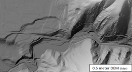
Download airborne lidar data from Open Topography and use QGIS to visualize and present the DEM and its derivative products.
Quick demonstration of the Suitability Modeler. Builds on the Habitat Modeling exercise.
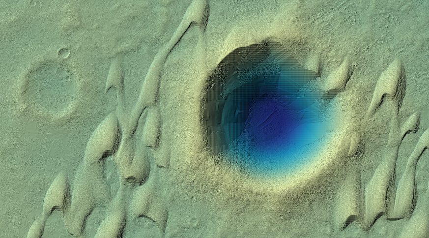
Calculate a DEM of difference to visualize and quantify the spatial distribution of elevation error.
This is a thorough introduction to ArcGIS Pro map and layout tools. Learn how to create projects, add data and manipulate the drawing order, change the way data is drawn on the map, and create professional map layouts.
Professional Practice Assistant Professor Director and Curator USU Museum of Anthropology Spatial Data Collection, Analysis, and Visualization Lab
Here we will explore basic modeling strategies with raster data.
Assistant Professor, Mathematics and Statistics Geostatistical techniques, spatial data visualization, machine learning
Use geoprocessing tools Create Random Points, Subset, and negative selection distances to map potential locations for 10 study sites. Use Network Analysis tools to calculate a loop route stopping at every site.
Explore the power (and countless nuances) of raster data: resolution, error, uncertainty, value attributes, and more.
Create map points from a table of coordinate values. Hopefully discover the importance of spatial reference systems!
Instructions for installing Windows patch to resolve symbology crashes
Create a composite binary raster model (combining elevation, slope, and aspect map layers) to predict potential habitat for Mexican spotted owls.
Associate Professor, Landscape Architecture & Environmental Planning GIS, geovisualization, environmental psychology
Calculate a kernel density surface from known coyote locations. Determine 50% and 90% probability of use areas. Add landcover to estimate preference ratios.
Instructions for installing Windows patch to resolve symbology crashes
A map series uses a series of features from a shapefile (study site polygons, river reaches, etc.) to automate creation of a series of matching map pages.
This exercise explores vector processing tools: Select by Attribute, Select by Location, Buffering, Clipping and more.
There are a few different ways we can manipulate coordinate systems in ArcGIS. As was said before, most spatial data we work with has already been assigned the correct coordinate system (the coordinate system that correlates with the values of the coordin...
Access synthesized global climate data from the NASA GISS Surface Temperature Analysis site. Hone cartographic skills to create a professional legend communicating highly complex data.
Information about the fallacies of the earth being round, the meaning of sea level, and gravity consistency.
Using spheroids and geoids, we can create a series of surfaces that combine these conceptual representations of the earth’s surface. Why create a series of surfaces instead of just one?
For better or worse, ArcGIS makes it easy for us to avoid the onerous task of truly understanding coordinate systems. This is unfortunate because it works directly against our ability to produce meaningful and defendable results.
You will work through three levels of pattern analysis: locational patterns, spatial auto-correlation of locations plus an associated value, and statistically significant clusters of locations sharing high values and clusters sharing low values.
Information on Cartesian coordinate systems for round objects as well as linear and planar units for flat object.s
Use a combination of tools to extract information from vector and raster map layers to summarize characteristics of a landscape.
Calculate a DEM of difference to visualize and quantify the spatial distribution of elevation error.
Explore how points, lines, and polygons explicitly map our world. Utilize vast tables of attribute data associated with mapped features to quantify and summarize map features.
Basics of cartography, layout, and sharing maps
Datums are one component of a geographic coordinate system (GCS). A GCS includes a datum, angular unit of measure, and a prime meridian. Datums are often thought of as geographic coordinate systems because it is very rare that the units are not degrees (v...
So how do we flatten a curved surface? Very carefully. Hopefully you have all seen or have tried the orange peel demonstration often enough to realize that there is no way to flatten a curved surface without stretching, shearing, and/or tearing it.
Learn about the basic raster surfaces: elevation, slope, hillshade, aspect. Use Zonal statistics to summarize raster values within defined areas.
Anytime you display data in a map document in ArcGIS that has a geographic coordinate system (or in this case datum) that differs from other data layers in your map document or that differs from the data frame display coordinate system
Combine raster and vector map layers to identify potentially suitable habitat locations based on known habitat criteria for a species.
Here we will explore basic modeling strategies with raster data.
Senior Lecturer, Environment and Society Co-Director, USU Geospatial Collective Director, GIS Graduate Certificate Program
Use elevation models to quantify drainage area to a user defined pour point. Derive a stream network and calculate stream order.
Download airborne lidar data from Open Topography and use QGIS to visualize and present the DEM and its derivative products.
Quick demonstration of the Suitability Modeler. Builds on the Habitat Modeling exercise.
Explore the implications of resolution and elevation source material for mapping, conservation, and understanding landscapes. Demonstration of downloading elevation data from the UT AGRC and the USGS National Map.
Using a sequence of raster calculations, manipulate the bedrock elevations of the Antarctic continent to estimate isostatic rebound and sea level rise.